Best Short Walks at
Aoraki / Mount Cook National Park
Discover some of the best short walks in Aoraki / Mount Cook National Park—perfect for all ages and fitness levels. These easy trails offer stunning alpine views, glacier-fed rivers, and up-close glimpses of New Zealand’s highest peak.
Want to experience the beauty of Aoraki / Mount Cook but short on time or worried about the physical challenge? We’ve got you covered. At New Zealand Private Tours, we’ve selected five of the most rewarding short walks that let you take in the region’s dramatic scenery—without needing to be an experienced hiker. These accessible trails offer incredible views of glaciers, valleys, and the towering peak of Mount Cook, making it easy for everyone to enjoy the magic of this alpine wonderland.
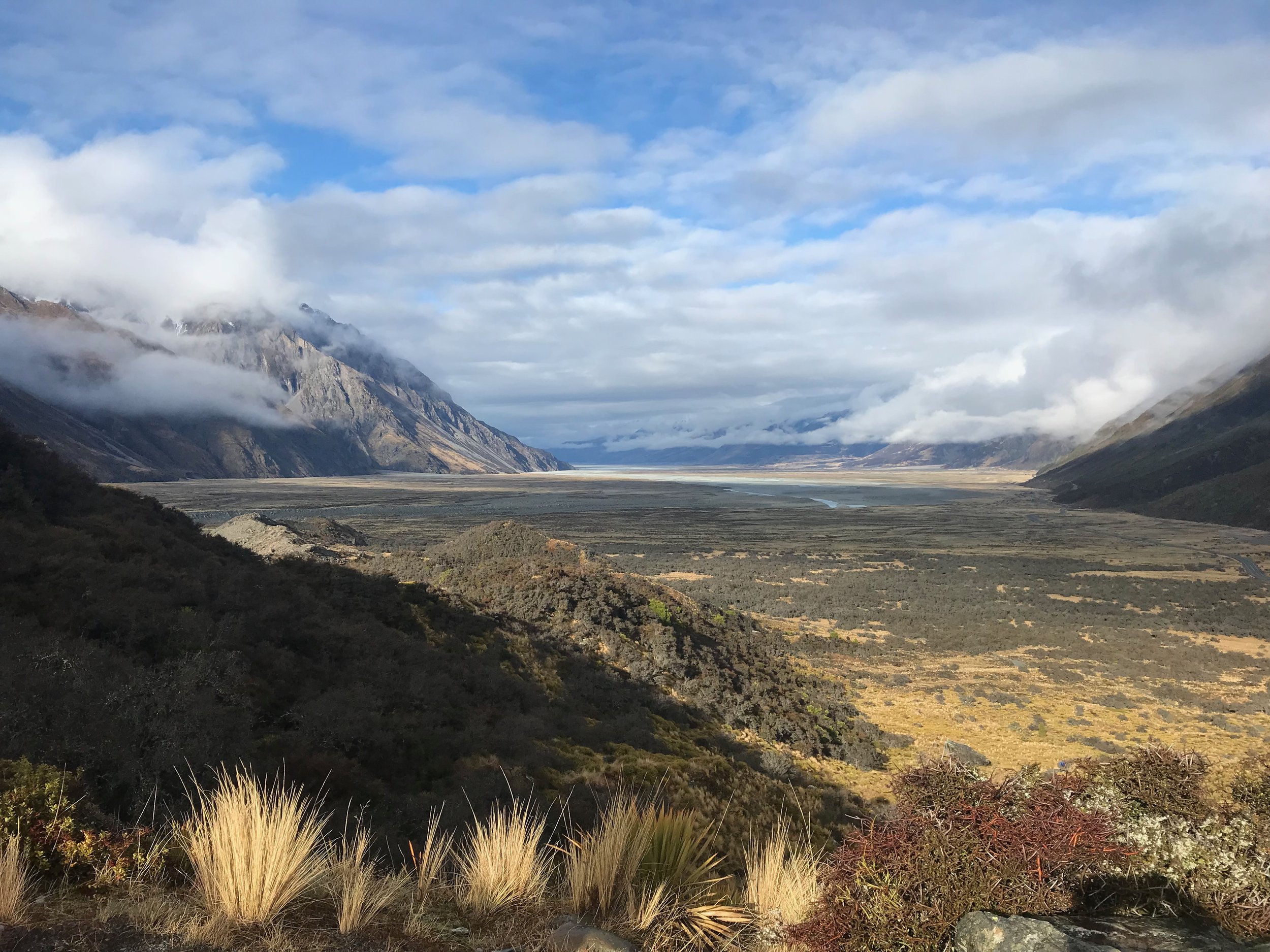
Hooker Valley Track (currently shut to second bridge)
Length: 10 Km (6.2 miles) return
Average time: 2.5 to 4 Hours
Height gain: 80 m (262 feet) over 5km (3.2 miles)
Distance from Mt Cook Village: 2 Km (1.25 miles)
Views of Aoraki Mt Cook: Yes
Views of a glacier: Yes the Hooker Glacier
Fitness level ( based on a semi fit 56 year old ): Low although quite long
Best time of the day to walk: Very exposed so can get hot in summer plus windy. Sunrise would be best however anytime is OK
Can you walk the track in winter: The track is open however can get very slippery in the shady areas due to ice not melting. It's a good idea to carry an inexpensive set of micro spikes (cleats) in winter. These are available from most outdoor sports stores or online.
-
Only rising 80 m (262 feet) it’s not steep and has a well-cared for track as it’s the most popular walk in Mt Cook so you will never be own your own. There are toilets at the start and at 3.5kms (2.2 miles) There are picnic tables once you reach the Hooker lake, however you will have to share. You can walk down to the Hooker lake and put your hand in the water. If you walk from the Mt Cook Village you need to add an extra ½ hour each way. There is a very busy carpark at the start.
Of the six walks listed this is the most popular and longest.
-
The track leads up the Hooker valley towards Aoraki / Mount Cook. It passes close to the Alpine Memorial (a great viewpoint) and Freda’s Rock before coming to the viewing point of the Mueller Glacier and the first swing bridge.
Cross the Hooker River here and carry on to the second swing bridge. Look out for many different wildflowers along the way, including celmisia and the kōpukupuku / Mount Cook buttercup.
The track from the first swing bridge to the second travels between old moraine ridges and humps. Past the second bridge, the vegetation changes to more open tussock and
a wider valley floor. A third swing bridge leads to the east Hooker and the source of the Hooker River. The track
ends at the glacier lake, where there are amazing views of Aoraki / Mount Cook, the Hooker Glacier and the Southern Alps / Kā Tiritiri o te Moana. Return the same way, enjoying more views down the valley and across to the Sealy Range.
Kea Point Track
Length: 2.8Km (1.73 miles) return
Average time: 1 to 1.15 Hours , add 1 hour if walking from village
Height gain: 180 m (262 feet) over 2.8km (1.73 miles)
Distance from Mt Cook Village: 2 Km (1.25 miles)
Views of Aoraki Mt Cook: Yes
Views of a glacier: Yes, Mount Sefton’s hanging glacier
Fitness level ( based on a semi fit 56 year old ): Low although quite steep
Best time of the day to walk: Very exposed so can get hot in summer plus windy. Sunrise would be best however anytime is OK
Can you walk the track in winter: Not recommended as very icy.
-
Rising 180 m (590 feet) parts of the track are a little steep and rocky however it’s still a well-cared for track. Once you get to the end there is a seat with a great view of Mt Cook. There are toilets at the start of the track. If you have a car or private driver there is a carpark at the start.
If you have time you can combine this with the Hooker Valley walk as they start at the same location.
-
This walk gently winds its way through subalpine grasslands and scrub to the Mueller Glacier moraine wall. The track passes through a landscape that was formed in 1913 when
a stream cut through from the glacier to the original Hermitage site, damaging the building. The walk ends at a viewing deck that gives stunning views of Mount Sefton, The Footstool, the Hooker Valley, the Mueller Glacier lake and Aoraki / Mount Cook.
Tasman Lake Track
Length: 2.5Km (1.6miles) return
Average time: 1 hour
Height gain: None
Distance from Mt Cook Village: 9 Km (5.6 miles)
Views of Aoraki Mt Cook: Yes however only the top
Views of a glacier: Yes, the Tasman Glacier
Fitness level ( based on a semi fit 56 year old ): Very low
Best time of the day to walk: Very exposed so can get hot in summer plus windy. Sunrise would be best however anytime is OK
Can you walk the track in winter: The track is open however can get very slippery in the shady areas due to ice not melting. It's a good idea to carry an inexpensive set of micro spikes (cleats) in winter. These are available from most outdoor sports stores or online.
-
If you have booked the glacier boat you won’t want to do this this walk as it’s the same place.
A well-cared for and flat easy track this is the easiest way to see a glacier plus large chucks of ice floating in the glacial lake. There are toilets at the start of the track, you will need to have a car or private driver as it’s 9kms (5.6 miles from Mt Cook Village, there is a carpark which can get a little crowded. You can make detour down to the place the glacier boats leave from and put your hand in the water, however there is a small hill to descend which is a bit rocky.
Of the five walks listed this would be the easiest and we think the best with the least effort.
-
Description text goes here
Tasman Moraine Wall Track
Length: 2.5 Km (1.5miles) return
Average time: 1 to 1.15 Hours
Height gain: 100 m (328 feet) over 1.2km (.75 miles)
Distance from Mt Cook Village: 2 Km (1.25 miles)
Views of Aoraki Mt Cook: Yes however only the top
Views of a glacier: Yes the Tasman Glacier
Fitness level ( based on a semi fit 56 years old ): Medium although quite steep
Best time of the day to walk: Very exposed so can get hot in summer plus windy. Sunrise would be best however anytime is OK
Can you walk the track in winter: Not recommended as can be very icy on the steps. It's a good idea to carry an inexpensive set of micro spikes (cleats) winter. These are available from most outdoor sports stores or online.
-
If you have booked the glacier boat you might not need to do this walk as looks over the same place.Rising 100 m (328 feet) parts of the track are a little and steep rocky however it’s still a well-cared for track. Once you get to the end there is a great view of the Tasman Glacier.
Of the five walk on our list this one would be the most tiresome as it’s all up hill however not as long as the Hooker Valley walk.
-
From the car park, walk past the Blue Lakes shelter and meander up past the Blue Lakes to a viewpoint on
the moraine wall.There are goodviews of the lower Haupapa / Tasman
Glacier and lake, icebergs, and the mountains at the head of the valley. A side
trip to the Blue Lakes offers good swimming in summer.At about 22 km long, the Haupapa / Tasman Glacier is the longest glacier in Aotearoa New Zealand. Unfortunately, glaciers the world over are shrinking, with the Tasman receding over 100 m per year.
Governors Bush Walk
Length: 1.2 Km (.75miles) loop
Average time: 1 Hours
Height gain: 100 m (328 feet) over 1.2km (.75 miles)
Distance from Mt Cook Village: 300 meters (.18 miles)
Views of Aoraki Mt Cook: Yes however only the top
Views of a glacier: No
Fitness level ( based on a semi fit 56 years old ): Medium although quite steep
Best time of the day to walk: Anytime of the day as covered by trees
Can you walk the track in winter: Not recommended as can be very icy on the steps
-
Nice bush track with native plants and a view of Mt Cook from the top.
Rising 100 m (328 feet) parts of the track are a little and steep rocky however it’s still a well-cared for track. Once you get to the top there is a nice view of Mt Cook.
Of the five walks on our list this one would be perfect if you don’t have transport as its very close to the Mt Cook Village, however a lot of the time you are surrounded by trees so the views are not as good as the other walks.
-
From the car park, it’s best to take the entry behind the shelter/toilets building.
There are good-views of Mt Cook at the top only, there is a also view of a waterfall/rapids on the Black Birch Stream
Lots of the trees have name tags so you can identify the local flora.
Experiences in Aoraki/Mt Cook National Park
Experience the dramatic beauty of Aoraki/Mt Cook National Park, where towering peaks, ancient glaciers, and alpine lakes create a breathtaking backdrop. From glacier boat rides on Tasman Lake to thrilling heli-hikes and scenic flights that land on the ice, there are adventures to suit every traveller. Explore our dedicated page to discover the best Mt Cook experiences and start planning your journey.
Looking to book this as a standalone day tour to Mt Cook?
New Zealand Private Tours specialises in custom multi-day New Zealand holidays. If you are looking to book this experience as a single-day tour from Queenstown, please visit our sister company, Remarkable Scenic Tours, our local Queenstown guiding team.